Just when you thought it was safe to put away your umbrella, we’re back on La Nina watch
Australia has been put on “La Nina watch” as meteorologists point to a likely cooling Pacific Ocean, which could bring more rain to parts of the country.

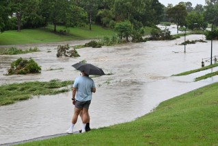
Cairns is expected to see heavy rainfall today.(ABC News: Michael Lloyd)
But the Bureau of Meteorology noted that despite the watch being in place, there was no guarantee that a La Nina would form.
There was now a 50-50 chance the weather system would form as sea surface temperatures had been steadily dropping in the central Pacific since late 2023.
“There are some signs that a La Nina might form in the Pacific Ocean later in 2024,” senior meteorologist Angus Hines said on Wednesday.
La Nina is a climate pattern involving cool ocean conditions off Australia’s east coast, which historically brings wetter-than-usual conditions for the nation’s northern and eastern regions.
The long-range forecast for the period from June to August predicted increased rainfall for some parts of the country, Mr Hines noted.
Higher-than average rain was likely for parts of Western and South Australia, he said, while there were “roughly equal chances” of above- or below-average falls in much of the east.
Record-high global sea surface temperatures observed each month between April 2023 and April 2024 meant that past experiences of changing conditions in the Pacific might not be reliable, the bureau said.
Current global ocean conditions have not been observed before, making it difficult for meteorologists to accurately predict future weather based on past observations.
The bureau in September declared an El Nino event, which typically brings drier-than-normal conditions and above-average temperatures.
But some parts of Australia still copped a soaking over summer as predicted dire bushfire conditions failed to eventuate.
Many firefighters have struggled to conduct backburning operations in the recent, cooler months, including NSW volunteers whose work has been stymied by a near-two-week-long wet spell.
“The return of wet weather has saturated the landscape making it too wet for effective burning,” NSW Rural Fire Service commissioner Rob Rogers said.
Essential hazard-reduction work had been delayed while the rain would also lead to more vegetation growth, increasing the risk for the next fire season, he said.
“April rainfall totals were also above average, setting us further behind and it is now unlikely that proposed hazard-reduction burn targets for this financial year will be met,” he said.


