Look out for Lincoln: On Brisbane’s wettest day since 2022 floods, another cylone forms in North
A third cyclone in as many months has formed off the Australian coast as rain-lashed regions brace for more wild weather.

Sailing upstream - this car found a watery grave near Helensvale. (Photo: ABC)
Wind gusts up to 110km/h and heavy rainfall are set to impact Gulf of Carpentaria coastal areas after Tropical Cyclone Lincoln formed on Friday.
It is set to make landfall as a category one system between the Northern Territory-Queensland border and the NT’s Port McArthur by Friday night.
“As it moves inland tonight, the system is expected to weaken and begin moving west across the central Northern Territory over the weekend,” the Bureau of Meteorology said.
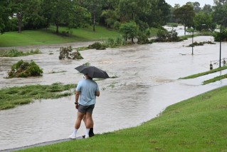
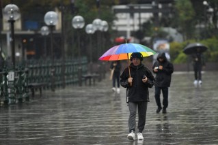
Meanwhile, heavy rain on Friday lashed Queensland’s southeast causing flash flooding and road closures.
In what was described as Brisbane’s wettest day since the 2022 floods, Rosalie recorded 197mm, Bowen Hills copped 135mm while 148mm soaked Mt Cootha.
Forecaster Steve Hadley told the ABC it was Brisbane’s “wettest day since 2022”, although there has been significantly less rainfall comparatively.
“On that day back in February, which had massive flooding effects, there were places on that day that had more than 300mm, quite widespread,” he said.
“So, a different sort of day, but the wettest one since then.
“It’s been a bit surprising how heavy it has been.
“We thought it would be less than a 10 per cent risk of being heavy this time yesterday, but it just appears that the easterly flow has sort of caused a trough and that’s converging right upon Brisbane and helping with the uplift of that air.
“And we’ve got an upper trough above us as well.”
In what was described as Brisbane’s wettest day since the 2022 floods, Rosalie recorded 197mm, Bowen Hills copped 135mm while 148mm soaked Mt Cootha.
Some regions in Lincoln’s sights are still reeling from the last cyclone. the remnants of ex-Tropical Cyclone Kirrily with more wild weather forecast.
A cyclone warning was issued for Gulf of Carpentaria coastal areas from the Northern Territory’s Bing Bong to Burketown in Queensland’s inundated northwest.
However, the system in the Gulf was only considered a low or “15 per cent” chance of intensifying into a cyclone on Friday afternoon.
It is set to move southwest towards the NT, cross the coast and move onshore on Friday afternoon.
“As it moves inland tonight, the system is expected to weaken and begin moving west across the central Northern Territory over the weekend and then over northern Western Australia bringing heavy rainfall to areas near its path,” the Bureau of Meteorology said.
A woman, believed to be an Indian national, has been found dead in a car submerged in northwest Queensland floodwaters left in the wake of ex-cyclone Kirrily.
The vehicle was spotted in the flooded Malbon River at Duchess near Mount Isa on Thursday afternoon.
It is believed the 28-year-old woman had tried to drive through a flooded causeway.
“Heart breaking tragedy in Australia: an Indian national lost her life in a flooding incident near Mount Isa, Queensland,” the Indian High Commission in Australia posted on social media on Friday.
“Deepest condolence to the family of the deceased.”
Some northwest areas are still isolated due to widespread flooding caused by ex-cyclone Kirrily which lingered for days after crossing the Queensland coast weeks ago.
Tropical Cyclone Jasper also caused record flooding in Queensland’s far north after making landfall north of Cairns in mid-December.
Some communities didn’t take any chances as the third cyclone of the season loomed.
In the NT, people were relocated from the Beswick community south of Katherine.
More than 60 residents were also evacuated from Burketown in Queensland’s northwest which has recorded 135mm of rain in the last 24 hours.
Burke Shire mayor Ernie Camp said while Gulf communities were used to some isolation during the wet season, the consecutive severe weather events had been taking a toll.
“Everybody is feeling a little bit nervous,” he told AAP.
‘It’s certainly draining our resources, mentally as well considering these events are so close together.”
Mr Camp said supplies have been dropped into the Aboriginal community of Doomadgee which has been cut off by floodwaters for more than a month.
A cyclone warning area has been declared spanning Bing Bong in the NT to Queensland’s Mornington Island on Friday.
As Lincoln approached, the bureau warned people in Borroloola, NT and surrounding areas to remain inside and stay calm with “dangerous” winds expected.
“Do not go outside if you find you are in the eye of the cyclone,” it said.
The bureau also urged people living between the Queensland-NT border and Burketown to take precautions and monitor alerts.
Besides heavy rain and gales, the cyclone is also set to bring higher than normal tides across the southern Gulf region, causing minor flooding to low lying areas.
The system is set to weaken as it moves inland over central NT during the weekend and then into northern Western Australia, bringing heavy rainfall.
But the bureau warned the system was at “moderate” risk of becoming a cyclone again if it reached waters west of the Kimberley in WA later next week.