Rain has stopped, flooding has eased – now it’s time to pick up the pieces of shattered lives
The full extent of southeast Queensland’s flooding damage may soon be revealed with rain finally set to ease.

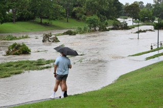
A flooded South Pine River is seen over a bridge in Strathpine, north of Brisbane, Tuesday January, 30th, 2024. Heavy rain has lashed an already soaked southeast Queensland, as ex-tropical cyclone Kirrily delivers more wet weather in the state's northwest. (AAP Image/Jono Searle) NO ARCHIVING
Thousands lost power, more than 20 schools were closed, roads were cut and 39 swiftwater rescues were completed as severe weather lashed the area on Tuesday.
Some of the worst hit were north of Brisbane in the Moreton Bay area and the Sunshine Coast, while Lockyer Valley further west was also inundated.
Queensland Premier Steven Miles said authorities had tried to assess the damage on Tuesday but crews kept getting called away for swiftwater rescues.
Dozens of homes are believed to be damaged in Bray Park alone.
There were concerns on Tuesday night for other people in the Moreton Bay area as well as the Sunshine Coast, particularly in the Caboolture River’s low lying catchment with rain continuing.
Evacuation centres have been set up in the Moreton Bay region where the SES responded to 100 calls for help.
A severe weather warning was current from north of Brisbane on the Sunshine Coast up to Bundaberg, with six-hourly rainfall totals between 80mm and 150mm possible through to Wednesday morning.
Severe thunderstorms were set to extend rainfall totals up to 250mm in some areas, leading to more flooding.
Mr Miles is set to outline financial assistance to be made available for flood victims on Wednesday.
“I want all Queenslanders to know wherever they are affected by these floods we will be there to make sure that they are supported through the clean-up and getting back on their feet,” he told Seven Network.
Mother Nature may also provide some flood relief to the southeast on Wednesday, with rain expected to drift north through the Wide Bay and Burnett areas.
By Wednesday night showers and storms are forecast for the tropical north but the southeast is set to be dry.
“We have dry weather on the way from Wednesday onwards and that should last us through to the end of the weekend,” a bureau spokesman said.
However heavy rain causing flooding is still lingering in the Mount Isa area in the state’s northwest due to the remnants of ex-Tropical Cyclone Kirrily, days after it crossed the coast.
There are flood warnings through much of southeast Queensland from the southeast up to Emerald and inland past Charleville.
Prime Minister Anthony Albanese met SES and energy workers who had helped residents in the Townsville region in the wake of Tropical Cyclone Kirrily.
The last of the 66,000 homes that lost power was set to be reconnected on Tuesday.
“It is good that the anticipated damage is much less than what was thought,” Mr Albanese said.
The remnants of Kirrily are still causing wet weather around Mount Isa in northwest Queensland days after the cyclone crossed the coast.
At Winton, all rural roads are cut with some properties set to be isolated for six to eight weeks due to floodwaters.
“Some of the crossings are at the highest (flood levels) some graziers have ever seen them,” Winton Mayor Gavin Baskett told AAP.
Floodwaters had also claimed Kynuna further north, including the famous Blue Heeler Hotel.