Storm surge warning as Cyclone Jasper heads toward FNQ
Far north Queensland residents are bracing for power, internet and water cuts as Tropical Cyclone Jasper bears down on the coast, bringing damaging winds, heavy downpours and flash flooding.
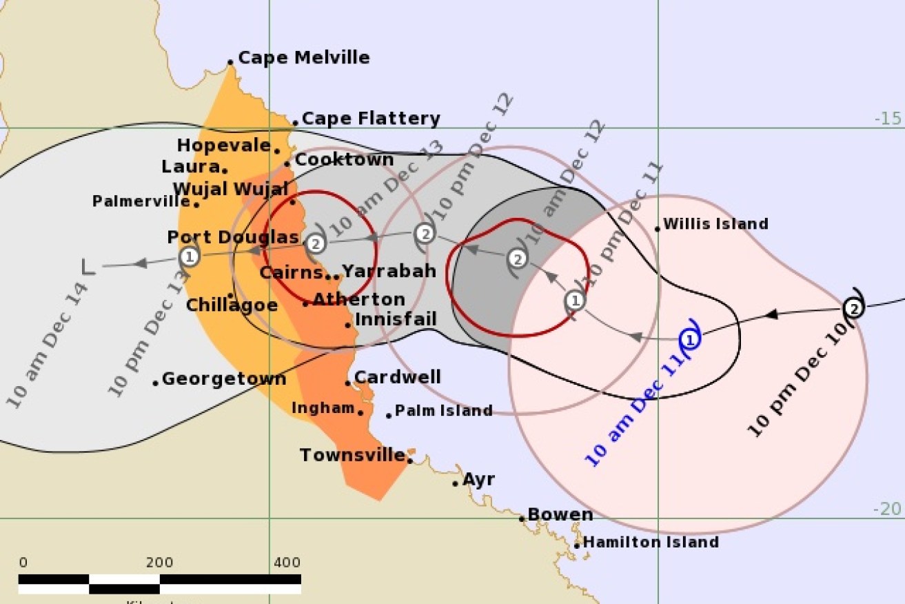
The Bureau of Meteorology says TC Jasper is now forecast to cross as a category 2 system on Wednesday, most likely between Cape Flattery and Cardwell and weaken as it moves inland during Thursday towards the Gulf of Carpentaria.
Evacuation centres have been set up and hundreds of support teams, including energy company workers, are heading north to assist as the cyclone approaches.
Jasper on Monday weakened to a category 1 system and was about 600km east of Cairns and 530km northeast of Townsville.
Deputy Premier Steven Miles said it was expected to re-intensify and make landfall between Cape Flattery and Townsville on Wednesday.
“While it’s currently been downgraded to a category 1 cyclone it is expected to re-intensify into a category 2,” he told reporters on Monday.
There is a significant risk of flash flooding and a storm surge for the Queensland coast stretching from Cairns to Townsville.
Cyclone Jasper is then expected to cross the Cape and impact vulnerable communities in the state’s north, Miles said.
A tropical cyclone warning was issued on Monday, effective from Cooktown to Townsville, including Cairns, Innisfail and Palm Island.
“A warning means we can expect impacts from the cyclone within 24 hours and this includes gale force winds,” the Bureau of Meteorology’s Laura Boekel said on Monday.
“At this stage the most likely scenario is we will see a category 2 crossing the coast sometime on Wednesday.”
Flood watch and flash flooding warnings are current for the north tropical coast, parts of the Cape York Peninsula and Gulf Country, the bureau said.
A cyclone watch is in place from Cape Melville to Cooktown and extends to Palmerville and Hopevale in the north.
Evacuation centres have been set up in Cairns, Port Douglas and Cooktown.
Cairns hospital is being prepared for a possible storm surge due to its waterfront location.
About 450 Energy Queensland staff have been deployed to Rockhampton and Townsville in preparation for potential power outages caused by Jasper.
A further 150 Energex crews are leaving southeast Queensland to assist.
“There will also be plans for isolated and vulnerable communities being put in place, but we are well prepared,” Energy Minister Mick De Brenni said.
“We encourage Queenslanders in the affected regions to make their preparations for loss of power supply now.”
Police will send around 40 officers to far north Queensland to assist areas impacted by the system, Commissioner Katarina Carroll said.
Queensland’s state disaster coordination centre has been activated in response to Jasper’s threat, as have district and local disaster coordination centres.
A severe weather warning for damaging winds was also in place for Monday in parts of the Herbert, lower Burdekin, central coast and Whitsundays districts, with the bureau predicting gusts of up to 90km/h in some areas.
Queensland Fire and Emergency Services warned residents between Cape Melville and Townsville strong winds could fell trees and powerlines, damage rooves and blow away anything not tied down.
Jasper could also cause phone and internet outages, along with water supplies, QFES warned.